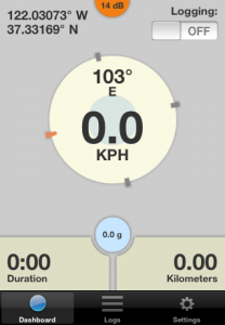
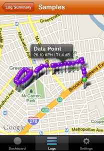
![]() I’m looking for some beta testers for my iPhone data logger application. I’m specifically soliciting bicycle riders to record their rides around New York City in support of my thesis research involving visualizing the cyclist experience. This is a proof-of-concept exploration in what a ubiquitous mobile sensor network could possibly look like, using existing technology that we already carry to learn about ourselves and our world.
I’m looking for some beta testers for my iPhone data logger application. I’m specifically soliciting bicycle riders to record their rides around New York City in support of my thesis research involving visualizing the cyclist experience. This is a proof-of-concept exploration in what a ubiquitous mobile sensor network could possibly look like, using existing technology that we already carry to learn about ourselves and our world.
I’ve chosen to focus on cycling in the city, but the concept is far-reaching (and I’m certainly not the first to approach this). Recently, The New York Times published an article [1] revealing findings from a year of GPS logged taxi cab data, summarizing average traffic speeds in Manhattan by day. Similarly, Cabspotting [2] visualized the taxi routes in San Francisco. Flight Patterns [3] reveals the air traffic over the United States throughout a typical day.
 Projects involving using the bicycle as a sensing platform have emerged as well. The Copenhagen Wheel [4] is a dense array of motion and environmental sensors packed into an electric-assist rear hub. While not cycling-specific, the Personal Environmental Impact Report [5] uses GPS-enabled mobile phones to infer mode of travel from speed and calculate your carbon footprint and exposure to air pollution.
I’m primarily looking to see if there are correlations in rider travel patterns. Are there commonalities in routes, sound levels, bumps? How are riders navigating to similar locations? What are typical trip durations and speeds? Do different types of riders (commuter, enthusiast, courier, racer, delivery rider) behave differently? When are riders on the roads? For all of this, what could it look like as visualization?
This application is the data collection mechanism I’ve chosen to employ for this exploration. It records location, heading, speed, altitude, accelerometer, sound level, trip duration and distance to storage on the device. Each log can be viewed on a map and individual samples inspected. Export logs via e-mail in CSV, JSON or Golden Cheetah format. Data can be automatically uploaded while recording as well.
 This application will be released as open source software under the GPLv3. Source code will be available at: http://github.com/rcarlsen/Mobile-Logger
If you’d like to participate in this beta test, please e-mail me the UUID for your iPhone (3G or 3GS, OS 3.1+) device. This can be retrieved in iTunes by connecting the iPhone via USB cable, and clicking on the Serial Number field in the device summary. After displaying the UUID, go to Edit > Copy to copy it to the clipboard.
The basic functions of the application are on the project page. If you’re simply interested in recording your trips and not specifically interested in contributing to the project then I ask you to wait for the public release of the free app in the App Store. An Android version of the logger is also forthcoming.
[1] http://www.nytimes.com/2010/03/24/nyregion/24traffic.html?ref=nyregion
[2] http://cabspotting.org/
[3] http://www.aaronkoblin.com/work/flightpatterns/
[4] http://senseable.mit.edu/copenhagenwheel/
[5] http://peir.cens.ucla.edu/
Leave a Reply
You must be logged in to post a comment.